

Reservoir Characterization in Southwestern Iran
Researchers have applied a new analytical technique to a proven reservoir in southwestern Iran to better understand its geological structure and potential. Using data from four wells in the Bahregansar and Hendijan fields, the study, published in Nature, utilized a Discrete Wavelet Transform to identify key geological surfaces and assess reservoir quality and geomechanical properties.
Wavelet Transform Methodology
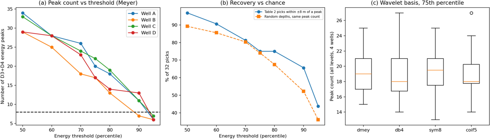
The research team employed a Discrete Wavelet Transform (DWT) using Meyer wavelets at detail levels D1 to D4 on gamma-ray logs. This analysis identified eight maximum flooding surfaces (MFS1-MFS8) based on local-wavelet-energy maxima. The number of surfaces identified varied between wells, ranging from six to thirty-four, with eight emerging at the 90th-95th percentile. Two change-point algorithms, Bayesian Online Change-Point Detection (BOCPD) and Pruned Exact Linear Time (PELT), were used to independently verify the identified surfaces.
Reservoir Quality Ranking
Based on delivered effective porosity (PHIE) and water saturation (Sw) curves, the reservoir quality was ranked as follows: A > C > D > B. Mean PHIE values were 0.159, 0.131, 0.099, and 0.091, respectively. This ranking remained consistent across 81 alternative cut-off combinations.
Geomechanical Properties
Well A exhibited the highest ductility (Brittleness Index, BI = 36.5), while wells B, C, and D were more brittle (BI values ranging from 53.1 to 61.5). The study suggests that the upper packages (MFS5-MFS8), representing the Ghar clastics, possess the best reservoir quality and lowest brittleness.
Pore Pressure Assessment
Sonic method data indicated that pore pressure is statistically indistinguishable from hydrostatic pressure. A preliminary overburden-bounded mud-weight window of approximately 9.8 ppg (hydrostatic pore pressure) is proposed. The researchers state that this pore pressure assessment requires further calibration with core data.
Limitations and Future Work
The workflow described is presented as a screening tool for mixed siliciclastic-carbonate reservoirs within the Zagros foreland. The researchers emphasize that the identified picks, petrophysical cut-offs, and geomechanical values have not been calibrated against core, biostratigraphy, or leak-off data. Further research is needed to validate these findings.
Source: Nature. Featured image credit: Nature.


Leave a Reply